Methane Emissions
Precision methane data:
spot leaks, slash costs, secure compliance.
1000+
products available on catalog
260
sites monitored worldwide
<24h
Crisis delivery
3
Services Levels
With its proprietary GESat satellite constellation, Sensing’s suite of products & services enables accurate identification and quantification of individual facilities’ methane (CH4) emissions.
No permits, no on-site access, no downtime — just reliable, independent insights available anywhere in the world, 24/7.
From pipelines to coal mines and offshore assets, we offer a range of products & services to address your investments, cost savings and compliance risks needs.
products
Products designed for accuracy
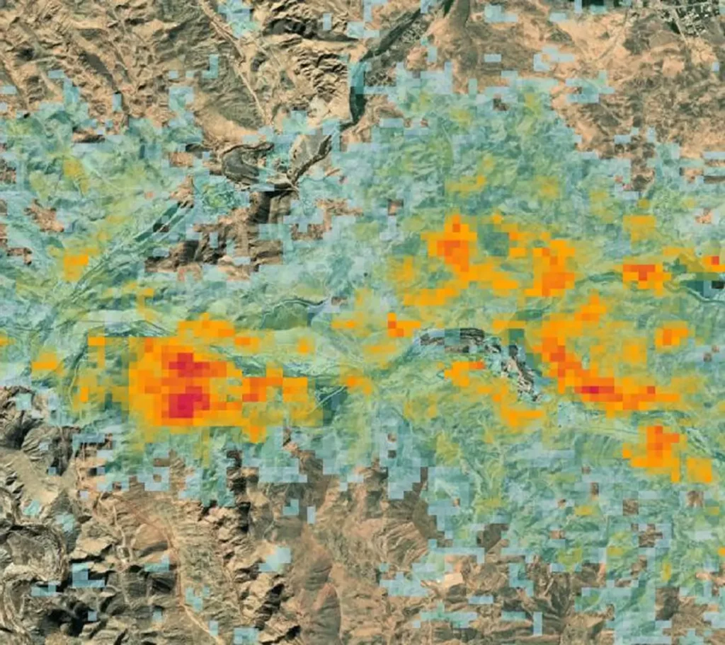
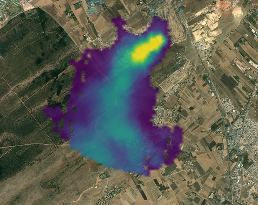
Concentration Maps
Visual and geospatial layers showing precise methane plumes overlaid on high-resolution ground imagery.
Each map comes with a GeoTIFF containing per-pixel concentration data, enabling detailed spatial analysis of emission sources and dispersion patterns.
Emission Rates
Quantified emission rates derived from concentration data using CEOS compliant methodology.
These numbers provide defensible, facility-scale quantification you can trust for reporting, mitigation planning, and risk assessment.
services
3 levels of services, one objective: actionable insight.
Most popular
Persistent Site Monitoring
Ideal for ongoing oversight and inventory validation of high-priority facilities.
Receive monthly methane concentration maps and emission rates delivered within >24 hours after acquisition.
€500/scan
per scan / 1 site / monthly subscription
Perfect for: Energy operators seeking continuous leak detection, repair verification, and compliance tracking; insurers and financial professionals monitoring long-term asset performance and transition risk.
on demand
Crisis Management Tasking
Urgent, one-off measurements activated on demand.
Fast-turnaround products delivered in <24 hours after satellite acquisition.
€1 000/scan
per scan / 1 site / no upfront payment
Perfect for: Rapid response to suspected leaks, incident validation, emergency reporting, or time-sensitive due diligence.
archive
Data Archive Access
Instant access to our growing archive of 1,000+ validated methane concentration maps and emission rate products of industrials sites worldwide.
Inclus dans l’abonnement PLUM
Perfect for: Historical trend analysis, benchmarking, portfolio screening, and back-testing risk models.
use cases
Persistent satellite eyes on your assets for durable operational resilience.
Detect leaks, reduce costs, prove compliance.
Satellite-based methane data empowers oil & gas companies and coal mines to detect and repair leaks with surgical precision, converting wasted product into direct cost savings while delivering independent, verifiable proof of compliance that protects margins and reputation.
By identifying super-emitters in real time, operators reduce downtime, avoid fines, and showcase proactive environmental performance that strengthens stakeholder confidence.
Transforming methane data into strategic information for investment.
Financial analysts and commodity traders leverage precise methane data to evaluate true asset value, forecast transition risks, assess supply chain exposure, and identify companies poised for long-term profitability in a carbon-constrained world.
Operators demonstrating strong methane control often command higher valuations, better access to capital, and favorable investor and trading sentiment.
Quantifying methane exposure to accurately price climate risk.
For insurers, high-resolution satellite intelligence enables sharper risk assessment, allowing them to design more competitive policies, reward low-emission operators with lower premiums, and differentiate their offerings in a crowded market.
Transparent methane insights turn climate-related uncertainties into quantifiable, manageable risks.
partnerships
Veolia is deeply committed to accelerating the decrease of its scope 1 and 2 emissions, a significant portion of which originates from the landfills we operate.
Direct and accurate monitoring of methane emissions is fundamentally strategic for us. It is the critical key to both improving our inventory methodologies and effectively steering our action plans aimed at mitigating these potent greenhouse gas sources.
The introduction of satellite monitoring by actors such as Sensing Atmospheric Intelligence offers a transformative leap in performance. By providing widespread, continuous, and high-resolution data, this technology allows us to pinpoint emission sources with unprecedented impact.
This capability will drastically improve the efficiency of our operational responses and provide indisputable evidence of the success of our current action plans.
— Antoine Lair
Landfill Business Support & Performance, Veolia
FAQ
Frequently Asked Questions
How does GESat data compare to other satellite methane products?
GESat GEN1 delivers superior quantification accuracy (>90%) compared to existing satellites. With its next generation active optical system and cryogenic sensor GESat GEN2 will go beyond pure accuracy by decreasing the detection threshold to <50 kg/hr for onshore and <100kg/hr for offshore assets, enabling confident attribution of small point sources missed by other satellites.
Can you monitor assets in cloudy regions or at night?
Yes. While emission quantification is disabled in very cloudy regions or at night, by fusing SAR and GESat data we maintain asset monitoring continuity regardless of weather or lighting conditions.
How quickly is data delivered after acquisition?
Standard delivery is within 48 hours of satellite overpass; our crisis management services offer accelerated delivery <12hours for time-sensitive applications.
Do you support integration with our existing ESG or operations platforms?
Absolutely. We offer API access, standardized data formats (STAC, GeoJSON), and professional services to embed our analytics into your workflows.